Sometimes plans change resulting in hitchhiking and a completely different section of the PCT.
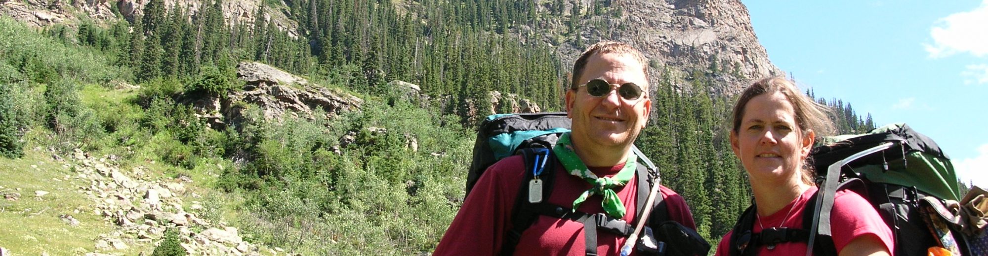
Backpackers: Carl Fisher and Ed Tucker
THE PLAN: Embark upon an easy (by PCT thru hiker standards) hike along the Pacific Crest Trail (PCT) of slightly less than 100 miles in 8 days. That equates to something like 12 to 14 miles per day. We read trail reports on the internet indicating the snow pack was high and some of the trails would not even melt out this year. We down played all of these reports by saying that the authors were over exaggerating OR that the warmer temps would work their magic and clear the trails. Since it was impractical and very expensive to rent two cars to position one at the end of the hike we decided to ride a cab to the trailhead at White Pass and to call at the end for pickup at Snoqualmie Pass.
August 7, 2011 We caught an early flight out of Green Bay WI to Seattle WA and arrived right on time at 11:00 am. We had previously arranged with a cab company to pick us up at 1:30 at a restaurant across from the airport. We built in this extra time to allow for late arrival and to give us time to unpack our travel bag, pack our backpack, and to give our non-hiking clothing and bags to a Kens Baggage and Frozen Food Storage at the airport. While being a bit on the pricey side it was easy and safe. With backpacks fully packed we “hiked” across the street to the 13 Coins Restaurant where we had lunch and awaited our cab.
The two hour cab ride (cost of $170) was not without incident. When we got to the turnoff for White Pass there were orange cones and the driver said, “Road closed, we go this way, only 5 miles further.” He was using a GPS for navigation and did not have a map. We went about 15 miles and the road was definitely heading in the wrong direction so he finally decided to turn around and stop to ask for direction from the park rangers we had passed directing traffic around a stalled vehicle. The ranger walked up to our cab with his hand on his pistol and a sour look on his face. As soon as the window was rolled down he asked, “Did you know it”s illegal to bring for hire vehicles into Rainier National Park and you”re going to have to return the way you came in? But first, I need to see your license, registration, and proof of insurance. That last comment was directed at the cab driver. The ranger took all that info back to his car and was gone for 10 minutes. During this time Ed and I were both trying to figure out now how we were going to get to the trailhead and how much it might cost us. There was no easy or short way to get to White Pass from where we were. Finally, the ranger returned, gave the driver a warning (not the ticket we had expected him to write), told us he would allow us to continue, that the cab driver could NOT return through the park and would have to take very long route home, and that we should give him a good tip. So the ranger was half nice guy and half ass. The road that the driver had thought was closed was, in fact, open and we arrived without further problems and gave him a $30 tip for his troubles.
We stopped at the Kracker Barrel Store and Services (509-672-3105) and picked up our previously arranged canisters of fuel. The walk to campsite at Leech Lake was along a highway for about 1.5 miles. Picked a campsite, set up camp, and went to the people in the site next to us to ask where the potable water was? Answer: back at the store! However, they were packing up to leave and had 2 gallons extra that they gave us – our first bit of trail magic on this trip. Nothing remarkable about the campsite. Temp in 60’s with lots of mosquitoes.
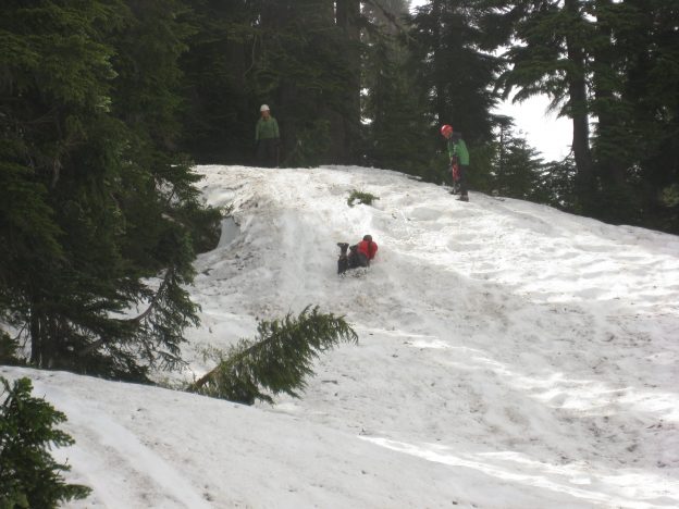
August 8, 2011(13.6 miles) We awoke to 50 degree temperature, a cool breeze to keep the mosquitoes down, and dew on everything. Found the PCT trailhead with ease and started out full of energy and high spirits. It were soon became obvious that no trail crews had been in yet as there were many and, I mean many, blow downs all the way from easy to step over to divert off the trail and bush whack to get around. We also early on encountered our first snow drifts. All in all there were about 50 blow downs and more than 50 snow drifts to navigate. The snow drifts ranged in size from a foot deep to more than 5 feet deep. Fortunately and unfortunately the drifts were ice crusted. Fortunately so that we didn’t sink in to the 5 foot of snow but unfortunately because they were slick and required concentration to not fall and to keep track of where the trail was heading. There were lots of mosquitoes throughout the day and especially near the Bumping River where we ended the day. SIDE NOTE: At the end of the day Carl was ahead of Ed in falling 2 to 1. We were hiking NOBO (north bound) and met a SOBO (south bound) hiker who was also camping for the night a Bumping River.
He did not recommend going any further. He said the drifts were 20 feet high, that the trail was covered quite a bit and n one stretch it was covered for ¾ of a mile and it took him 4 hours to traverse. He also felt that his life was threatened in several of the narrow passes with sharp drop offs. Given this information Ed and I decided to turn around, cancel our 8 day hike, and return to Leech Lake to figure out how to get back to Seattle. We didn’t relish the thought of paying another $170 or god knows how much to another cab company.
August 9, 2011 (13.6 miles) Nothing remarkable about today as it was the same trail as yesterday. We ended the day at Leech Lake again in the same campsite as our first night. Carl fell once again so he is leading in the falling game 3 to 1 but Ed has the lead now in a new category BENT POLES – Ed 1 to 0. Ed had a near fall that we averted by his pole which took the brunt of the force. Our plan was to try to hitch a ride back to Seattle the next day and spend the night again at Leech Lake again if we were unsuccessful. We heard construction equipment on the White Pass road all night long.
August 10, 2011 We got up at our normal 6:00 AM to a mist covered Leech Lake. Ed joked that with our luck White Pass was closed for construction and we wouldn’t be able to hitch a ride.
Well, no problem, I said as the nearest town was only 20 miles and we could just walk there. We packed up and headed to the Kracker Barrel Store and Services where we would first attempt to hitch a ride. After 30 minutes and no cars going by (only construction equipment) we decided to start walking. After a mile the road got dangerously narrow and we decided to go back to the country store. On the way we talked to one of the construction workers and, you guessed it, that road WAS closed due to blasting! Well at least we had tents, food, and water.
I went into the store while Ed stayed at the road with his thumb out, just in case. I asked the clerk if she knew of anyone heading to Packwood (the city that was 20 miles away). She gave me a curt, “No.” I went over to a table, set my book down, and headed for the coffee machine as Ed and I had agreed to take 30 minute shifts at the road and I had the first one in the store. Before I could get my coffee a guy walks up and asks if I was trying to get to Packwood and if so he could get me to Hwy 123 (about 8 miles from Packwood) and was I interested? I gave him an immediate yes because Hwy 123 was outside the blasting range and had a lot more traffic, increasing our odds of hitching a ride. However, I said, “There are two of us with backpacks and we haven’t showered in a couple of days. His response was that there were three of them with backpacks and rescue gear, a dog, and hadn’t showered in a couple of days. That sounded like a match made in heaven.
As we neared Hwy 123 the driver who now knew we were really trying to get to Seattle said they lived in Seattle and were heading that way but had to stop for about an hour of training and if we wanted we could ride along with them. Oh, I should point out that two of the three folks were members of the King County search and rescue team out enjoying personal time on the trail and had decided to call it quits for the same reasons we had. They were stopping to practice self arresting with an ice axe. We jumped at the chance to get closer to our final destination, a Motel 6 near the SeaTac airport. During our lunch stop the driver was puzzling over the map and asked us where we thought the best place was for us to be dropped off (he was an engineer and planner by nature). Long story short, we got dropped off at the exact Motel 6 we had planned to stay at. This was our second bit (and it was a big bit) of trail magic for the trip.
Now we will fast forward. No cheap flights home (all more than $300 to change) so we decided to stay, rent a car, and hike in Oregon.
August 11, 2011 We rented a car at noon, drove south to Vancouver WA, and prepared to begin hiking the next day.
THE NEW PLAN: Begin hiking at the Bridge of the Gods along the PCT for 12 to 14 miles and camp for the night. Then hike 10 or so miles to another campsite and on the third day hike out along the Eagle Creek Trail where we knew there were some excellent waterfalls.
August 12, 2011 (13 miles-including repeat miles) We were unable to secure a map of the area and for the first time ever (at least for me) started a hike without a map. The trail we were hiking on was paralleling the Columbia River for about 4 miles, at a gentle uphill grade and that didn’t feel right. Since neither of us had seen a PCT blaze (a marker on the trees that indicates the trail) in a while we figured we had missed a turnoff for the trail. Without a map we had no way to know so we turned around. About ¾ of a mile later we saw a blaze, turned around, saw another blaze and realized we had been on the right trail all along. Oh well, we learned the value of a map.
A couple of hours later our next bit of trail magic occurred. We encountered 4 hikers that were headed for the trailhead we had left earlier in the morning. We asked if they had a map so we could see where we were. They showed us and asked if we had a map. We sheepishly had to say no and they offered us their map as they were almost done using it. Of course, we accepted. Later in the day we came upon another hiker heading out who gave us the trail guide section write up for the section we were hiking – our final bit of trail magic.
The trail was excellent which we appreciated it because there was 4100 feet in elevation gain and several nice views of the Columbia River, Mt Rainier, and Mt Hood. We camped at a site 1/10 of a mile away from Camp Smokey. The water source was actually just a seep but didn’t cause us any serious issues. FALL SCORE: Carl 3 to 1
August 13, 2011 (4 miles) I slept in till 6:40 this morning! We decided to take trail number 434 which is a connector to the Eagle Creek trail. The hike was a very steep downhill trek on a trail that was no longer being maintained. There were large quantities of loose rock which is makes hiking treacherous and doubly so with a heavy backpack. We took numerous breaks as our thighs were burning. Carl and Ed both fell once, however, Ed also bent is hiking pole once again. FALL SCORE: Carl 4 – Ed 2 POLE SCORE: Carl 0 – Ed 2.
Our pace was less than one mile per hour but we still reached our intended campsite (Blue Grouse Camp) well before noon. After setting up camp we hike about ½ mile to Tunnel Falls which is simply awesome.
August 14, 2011(8.5 miles) The Eagle Creek trail from Blue Grouse Camp to the trailhead is essentially all downhill, well graded with good tread. There are several smaller waterfalls along the trail and for the most part this was an easy walk today. After the 6 mile hike to the trailhead we then walked 2.5 miles on a path next to the highway back to where we had left the car. We arrive before noon, loaded up and decided to head back to Seattle where we had dinner at our favorite restaurant in the area, The Crab Pot in Bellevue WA.