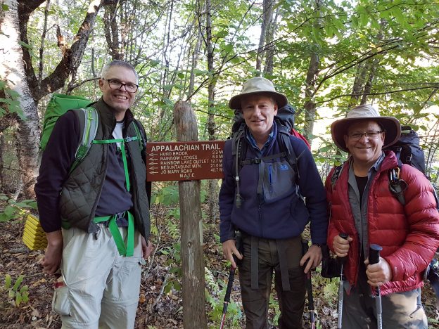
The final 100 miles of the Appalachian Trail (AT) that ended in reaching the summit of Mt Katahdin in Maine.
Backpackers: John Gundry, Carl Fisher and Pete Allington
September 26, 2016 – Miles: 11 We hit the trial at Abol Bridge at 8:15 after a shuttle ride. There was nothing real remarkable about the day except for lots of roots and rocks-which we’ve heard is most of the trail. Carl had low energy in the PM, even with easy trail, and the beginnings of a blister on his small, right toe. We camped at the Rainbow Spring Campsite.
September 27, 2016 – Miles: 14.5 We woke last night to rain at 2:00AM which stopped around 3:00AM and then started again at 4:00AM. When the rain slacked off at 6:30AM we quickly got out, packed up, and had breakfast. The rain ended around 8:30AM but the sun didn’t come out until 4:00PM. Another tough day for Carl who didn’t pull into camp at State Campsite until 6:00PM. Dry insides of the tents was a big plus. We ended up cooking in the dark but the site does have a picnic table. Light rain started again at 8:00PM.
September 28, 2016 – Miles: 15 It only rained for a couple of hours last night but we still had to pack slightly wet tents. Most of the hiking today was flat with OK tread. Most of the day was flat with OK tread. There was one climb. It wasn’t too hard since it was over before I realized we had done the climb. We recovered our resupply at Jo Mary road where we found a nice camp for the night.
September 29, 2016 – Miles: 15 This was another tiring day for Carl and it was pretty cold-near freezing. We have started the assent of White Cap Mountain and are about 1/3 of the way up. It is really cold and dark so we are all in our tents early. We are at Logan Brook lean-to but are choose tents as they might be warmer.
September 30, 2016 – Miles: 13 It was really cold last night. Carl used both of the sleeping bags (both 40 degree rated) so he was toasty. There was an immediate uphill which really got the heart going. The views from the top of White Cap Mountain are fantastic. After several ups and downs we found a campsite at West Branch Pleasant River.
October 01, 2016 – Miles: 11.5 No notes from today’s hike other than “roots and rocks”. Camp for the night is at Cloud Pond lean-to. We decided to stay in the lean-to which worked out well. We were by ourselves and had little to no issues with mice.
October 02, 2106 – Miles: 12.5 We camped at Little Wilson Stream.
October 03, 2106 – Miles: 7.5 The hike ended at Highway 15 where we had cell reception so we called Phil who came and picked up Pete (the fastest hiker) to recover our car. Carl (the slowest hiker) arrived to Highway 15 just as Pete returned with the car.